Page
About the Digital Archive
The COTCA Digital Archive holds (and makes publicly accessible) data relating to its case studies (e.g., “The Japanese occupation of China, 1937-1945”). The materials in each case study are drawn from collections held in various archives and libraries around the world, with details of the provenance of such data attached to each item. By collating materials held in various collections, the COTCA Team makes it possible for users to examine materials that have, in many cases, not been digitised before. It also enables users to trace visual and other themes across specific periods, and across different parts of “occupied” Asia. The COTCA Project acknowledges the assistance of staff at the Asian Reading Room at the Library of Congress; the East Asia Library and the Hoover Institution at Stanford University; the Asia Department of the British Museum; the Imperial War Museum; the National Archives (London); and Shanghai Library’s Modern Documents Reading Room.
Read More
Page
Privacy & Cookies
The COTCA Project may process and store your personal data when you visit this website to ensure the best possible browsing experience. Without some of these features the website simply would not work. We use cookies to allow us to understand which areas of the website visitors look at and which parts of the site they find most interesting and useful. For more information please see the University of Nottingham privacy policy.
Read More
Item
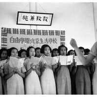
A chorus group [sic]
From a collection of staged photographs produced under the title “Life at a Girls School in Peking”, and produced at the Peking Jiyu Gakuen in Japanese-occupied Beijing.
Read More
Item
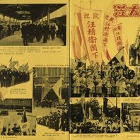
Damin cover image, May 1940
This is the cover image of the magazine Damin 3.3 (May 1940), published by the Daminhui (Great People’s Association) in Nanjing. The Daminhui was a propaganda and mobilization organization established by the Japanese in 1938, which was later folded into Wang Jingwei’s Kuomintang (Nationalist Party). The Daminhui specialised in public expressions of support for the occupation, and employed a staff of Chinese organisers, artists, and writers. The sun-and-moon logo of the Daminhui can be seen on this magazine’s cover.
Read More
Featured Item
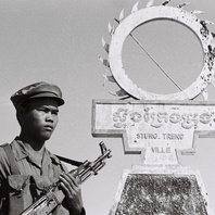
Armed soldier of the Kampuchea United Front for National Salvation
This unattributed image of armed soldier of the Kampuchea United Front for National Salvation (KUFNS, also known as FUNSK) [Front or Renakse] at the entrance of Stung Treng Municipality (northeastern Cambodia) is taken from a low angle. It shows the head and upper torso of the soldier. The man firmly holds his rifle and looks extremely focused. The other half of the picture shows the sculpture-symbol at the entrance of Stung Treng, a dented circle on a pedestal. This image was featured in the publication (French and English versions) entitled The People’s Republic of Kampuchea (1979). This photograph is part of the collection held by the Agence Khmère de Presse (AKP) and Cambodia’s Ministry of Information. This collection, which documents the early years of the People’s Republic of Kampuchea as photographed by the Vietnamese and a small team of Cambodian photographers, has not yet been classified or indexed.
Read More
Featured Item
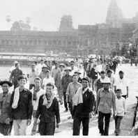
Crowds visiting Angkor Wat
This unattributed photograph shows a group of Cambodians on their way back from visiting Angkor Wat. The temple is visible in the background. The visitors are mostly men, with a few children and teenagers, with the people at the front smiling at the photographer. This photograph is part of the collection held by the Agence Khmère de Presse (AKP) and Cambodia’s Ministry of Information. This collection, which documents the early years of the People’s Republic of Kampuchea as photographed by the Vietnamese and a small team of Cambodian photographers, has not yet been classified or indexed.
Read More
Featured Item
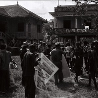
Posters being distributed to villagers
This photograph shows soldiers distributing illustrated posters celebrating the Kampuchea United Front for National Salvation (KUFNS, also known as FUNSK) [Front or Renakse] to a group of villagers. It is part of a series that describes the same group of villagers and soldiers. This photograph is part of the collection held by the Agence Khmère de Presse (AKP) and Cambodia’s Ministry of Information. This collection, which documents the early years of the People’s Republic of Kampuchea as photographed by the Vietnamese and a small team of Cambodian photographers, has not yet been classified or indexed.
Read More
Featured Item
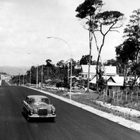
Newly laid road in Sihanoukville
This unattributed photograph shows a car travelling on a newly laid asphalt road connecting Sihanoukville and Phnom Penh in the mid 1960s. The photograph is part of the collection that was donated to the National Archives of Cambodia from the Library of the Royal University of Fine Arts by Darryl Collins and Helen Grant Ross in 2003. The collection was used by Collins and Ross for their research into urbanisation. The images were probably originally used to mount the Sangkum Reastr Niyum Permanent Exhibition at the Exhibition Hall, Bassac area, Phnom Penh.
Read More
Item
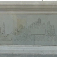
Win-Win Monument bas-relief
This photograph provides a view of bas-relief on the 117-metre-long engraved base of the Win-Win Monument. This section celebrates the achievements of different ministries, in this detail the Ministry of Tourism. The ministry is represented by a carving of Angkor Wat on a Naga (a mythological part-human part-cobra creature). The Win-Win Monument complex – photographed here in January 2020 – was inaugurated in December 2018 to mark the twentieth anniversary of the end of the post-Democratic Kampuchea civil war, with the final defection of the remaining Khmer Rouge factions, thanks to the DIFID policy (“Divide, Isolate, Finish, Integrate, Develop”) also known as the “Win Win” policy of Prime Minister Hun Sen.
Read More
Item
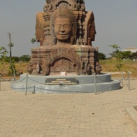
Miniature monuments at the Win-Win Monument complex
This photograph shows a miniature reproduction of a four-faced Buddha statue at the Temple Bayon (Angkor Wat). A garden located on the northern side of the Win-Win Monument complex displays several miniature reproductions of iconic Khmer monuments. The Win-Win Monument complex – photographed here in January 2020 – was inaugurated in December 2018 to mark the twentieth anniversary of the end of the post-Democratic Kampuchea civil war, with the final defection of the remaining Khmer Rouge factions, thanks to the DIFID policy (“Divide, Isolate, Finish, Integrate, Develop”) also known as the “Win Win” policy of Prime Minister Hun Sen.
Read More
Essay
The Malayan Emergency: Digital Map
Introduction Spaces of the Malayan Emergency is a digital map created as part of the ERC-funded COTCA Project. It is an interactive map of British Malaya in the 1950s, and is the first such map to ever be compiled using data related to the spatial dynamics of the Emergency and its related resettlement policies. The map is designed to highlight the variety of spatial and cartographic features that were hallmarks of the Emergency period in Malaya, including White and Black Areas, New Villages, Regrouping Areas and Detention Camps. Each layer of the map includes clickable data points that contain information about each spatial feature, including population figures, village class types and the source materials that list each location. In its totality, the map provides an approximation of how Malaya’s spatial environment was transformed under British colonial rule during the Malayan Emergency, and the ways in which the geography of Malaya was reshaped by British policies during this period. The data for this map was gathered from archives in Malaysia, the United Kingdom and elsewhere, as well as from a wide range of published secondary historical materials. We have made the geodata and map layers for this project publicly available. Users can access the data files by clicking on the red “View Map” button below. View map The map was generated using Mapbox. Dr David Baillargeon is the lead organiser, researcher and “map maker” for this phase of the COTCA Project; his work with the data provided in this map will appear in an article entitled “Spaces of Occupation: Colonial Enclosure and Confinement in British Malaya”, forthcoming in the Journal of Historical Geography. Spatial Categories The spaces that are covered in this digital map include the following: 1. Black Areas / White Areas Black Areas and White Areas were created in September 1953 under the direction of Sir Gerald Templer. Black Areas, which on the digital map are symbolised using a single polygon feature, were areas in Malaya that represented high-risk environments for anti-colonial “terrorist” activity. These spatial zones were subject to a variety of repressive government policies, including but not limited to curfews, food restrictions and travel bans. White Areas, however, existed in opposition to Black Areas. While the denotation of a “White” area meant the relaxing of some repressive restrictions enacted under the Emergency orders – mainly curfews and food controls – it was also meant to symbolise to the public the benefits of resisting communism and working closely with the colonial authorities. With time, however, the government expanded the programme, pronouncing large areas across Malaya “White” in an effort to instill hope for Malaya’s population. Such declarations were accompanied by the publication of a map in local periodicals and government gazettes that included the precise contours of the area in question, as well as literature about the new “White” area regulations, written in both Chinese and Malay. While information about White and Black Areas can be found in a variety of locations, the specific details of the Black Areas polygon in the digital map is copied from data found at The National Archives (London), Colonial Office files, CO 1030/1, Emergency Regulations: Declaration of “White Areas”. 2. New Villages The British colonial government in Malaya created New Villages to relocate the colony’s large rural ethnic Chinese population into more concentrated and governable spaces. The government took these actions beginning in 1950 under the Briggs Plan in an effort to cut off supplies – mainly food, money and military provisions – to the MCP and MNLA, who were largely based in the jungle. These New Villages, which were initially labelled as “resettlement areas”, were then sectioned off using barbed wire and perimeter fencing, and all movement in and out of the villages was strictly controlled. British planners incorporated a number of common buildings and communal sites across New Village spaces, including schools, community centres and garden plots. Although statistics on these resettlement efforts vary, the British forcibly relocated approximately 500,000 people into around 450 New Villages across British Malaya. The vast majority of those resettled in New Villages were ethnic Chinese “squatters” who, until the Malayan Emergency, had been living throughout the Malay interior. Although statistics related to resettlement sites exists in a variety of published and archival sources, the most comprehensive list of New Villages is found in W. C. S. Corry’s 1954 study, A General Survey of New Villages. This list provided the data source for the New Villages detailed in this digital map. It should be noted that while most layers within the digital map have limited statistical information, New Villages are an exception. This is because the data for New Villages is far more robust than for other spatial categories within the map. Because of this, rather than simply providing the name and source information for each site, the clickable data box for each New Village contains information about the place name, approximate population, type of local government, and “category” of construction. While most of this data is self-explanatory, it should be noted that the “category” designation for each New Village represents the following: (A) refers to New Villages that were entirely new in their creation; (B) refers to New Villages built around smaller old villages that were then absorbed into the New Village; and (C) refers to New Villages that were suburbs or appendages to already existing towns or large villages. The definitions for these categories was found in Arkib Negara Malaysia, ANM, 1979/0006541, Statistical Information Concerning New Villages. 3. Regrouped Malay Kampongs One spatial designation rarely discussed within the historiographical literature on the Malayan Emergency is the Regrouped Malay Kampong. According to Paul Markandan, whose 1954 book, The Problem of New Villages in Malaya, represents one of the few secondary sources on this topic, the regrouping of Malay kampongs (or villages) began across the colony after 1952 in an effort to resettle Malay rural dwellers closer to main roads and police protection. There were many differences between these regrouping spaces and New Villages. First, Regrouped Malay Kampongs primarily consisted of Malay people, rather than those in the Chinese community. Second, the regrouping of Malay people occurred voluntarily instead of forcibly, and many Malay people who resettled were compensated for doing so. Third, and perhaps most importantly, these spaces were not subject to spatial control in the same ways in which New Villages were. In fact, instead of barbed wire fencing, perimeter lighting and the construction of recreation and educational centres, Regrouped Malay Kampongs contained few if any of these attributes, and local Malay villagers often had to finance the building of their own dwellings and communal institutions. Security for these villages was provided by the colonial Home Guard. Although statistics about Regrouped Malay Kampongs are limited and colonial administrators did not record their numbers in every state, the data for regrouping areas included in the digital map were found in the Arkib Negara Malaysia, ANM, 1979/0006541, Statistical Information Concerning New Villages. Data is provided for the states of Johore, Kelantan, and Pahang. 4. Labour Regroupments Another spatial category novel to the Malayan Emergency that receives little attention in the scholarly literature is the Labour Regroupment. Labour regrouping occurred at large rubber plantations and mining sites, most of which were owned by Western companies. The British colonial government considered labour regrouping necessary because, at the onset of the Emergency, many workers at these extractive and agricultural sites – whether Chinese, Malay or South Asian – lived in rural areas outside the boundaries of the company lease. Labour regrouping meant that companies were required to resettle their workers within the grounds of their estate to prevent them from being attacked by communist insurgents or, conversely, to prevent them from aiding the MCP and MNLA. Labour regrouping, however, was controversial, especially within the commercial community. Because regrouping forced firms to construct new living quarters and other amenities for their workers, many companies appealed to the colonial government to help finance such measures, which the British administration was reluctant to do. Nevertheless, labour regrouping occurred on a large scale throughout the colony. Unfortunately, the only statistics that we’ve discovered for such measures exist for the state of Pahang. This data, which is made available in the digital map, was found in the Arkib Negara Malaysia, ANM, 1979/0006541, Statistical Information Concerning New Villages. 5. Detention Camps The final spatial designation rendered in the digital map is Detention Camps. Although few in number and most often located in Malaya’s urban centres, Detention Camps operated as sites of incarceration, rehabilitation or “repatriation” throughout the colony. This category, it should be noted, is varied in its orientation. Although five of the spaces defined as “Detention Camps” were noted to exist in 1951 – one in Tanjong Bruas (Malacca), one in Majeedi (Johore), one in Pulau Jerejak (Penang), one in Ipoh (Perak) and one in Kluang (Johore) – there are two other sites listed in this category that are not strictly Detention Camps. This includes a “Transit Camp” in Port Swettenham and a “Rehabilitation Camp” in Taiping. The latter such facility was noted as housing Chinese people between the ages of 16 and 40 who were specially selected from the other Detention Camps to receive four to six months of vocational training. These inmates would later be re-released into the general population. In total, in December 1950, approximately 10,241 people were noted as being in detention. Data for these camps was found in The National Archives (London), Colonial Office files, CO 537/7270, Malaya: Detention, Repatriation and Resettlement of Chinese. Limitations of the Map The Spaces of the Malayan Emergency digital map provides an interactive tool to investigate and visualise the spatial features of the Malayan Emergency. Nevertheless, the map has a number of limitations that are worth noting. Rather than operating as a StoryMap or a map that reveals change over time, this map provides a visual snapshot of a particular moment in time during the Malayan Emergency. Roughly speaking, that moment is the year 1954. We chose to create a “static” map for a variety of reasons. First, the data and statistics related to the Emergency – particularly the names and locations of New Villages – were best reported and most readily available for the period around 1954. We thus chose this moment as being representative of a time when many of the Emergency’s unique spatial features were all in place territorially – for example, a moment when most New Villages and Regrouping Areas had already been built – but prior to a time when some other significant spatial categories – mainly Black Areas – still existed on a map. In other words, while prior to around 1952, many New Villages and Regrouping Areas had yet to exist in the colony and are therefore unable to be mapped, after around 1955, many Black Areas in Malaya had turned into White Areas. These realities also make the creation of a StoryMap difficult. While the strength of a StoryMap is in its focus on temporality, the data and statistics that are available in the archival record about these spatial features – with the possible exception of New Villages – is largely incomplete. While there is therefore much value in showing how British administrators created New Villages in the colony over time, it would be nearly impossible to do so while also including other spatial categories created during the Emergency, including Regrouped Malay Kampongs and Labour Regroupments. In addition, because the exact cartographic contours of White and Black Areas shifted rapidly over the Emergency period, the data available in the archival record would make it difficult to accurately track these variations over time. Even still, the use of a “static” map creates the appearance that the geography of the Emergency was “fixed” in its spatiality, which most certainly was not the case. This map merely represents an approximation of the spatial transformation that occurred in Malaya during the Emergency period. In other words, the map should not be considered a final statement on what the Emergency “looked like” during the 1940s and 1950s, but rather a visual tool designed to help scholars and the public better understand the scale of the spatial transformation that occurred during the conflict. The other major limitation of this map is related to data. While in some cases – such as for New Villages – statistics and information about different sites of occupation is readily available, that is not the case for all spatial designations referenced in the digital map. Statistics for Regrouped Malay Kampongs and Labour Regroupments, for example, were not always reported by British officials in the colony, and the available information depends heavily on how particular state administrators – i.e. officials in Johore, Pahang, or Perak – listed particular sites. This latter point on reporting data is important. Although a certain site may have been listed as a New Village in one source, for instance, that same site may be listed as a different spatial category elsewhere in the archive. In such cases, we relied on published sources – particularly Corry’s A General Survey of New Villages – to provide a more final assessment of how a site should appear in the digital map. Nonetheless, it should be noted that data points in the digital map are fluid in their orientation, and that British officials and members of the local community may have defined that site differently than what exists in the archival record. Similarly related to issues about data, there are questions involving the location of certain place names within the map. While some New Villages, for example, remained inhabited and even grew in population and territory over the post-colonial period, others – particularly those in more rural spaces – were later abandoned. Some others changed their names. This means that while some sites are easy to geolocate (and, it should be noted, this represents the vast majority of these spaces), others are much more difficult to find. In some cases, when a place name may have gone out of favour but road names and commercial enterprises happened to retain the earlier place name, we used guesswork to estimate the location of a particular space. However, it should be noted that not all locations are in the precise place where they may have existed originally. Finally, we chose not to include photographs of specific sites that are listed in the map. This is because although there are a number of excellent online digital databases that include photography from the Emergency period, very little of that material is catalogued as being from a particular location. In other words, there are many photographs of “New Villages” in the archival record, but few that record the actual place name of each New Village site. Because of this, and because visual materials could only be found for a tiny fraction of the sites included in the digital map (less than 2 per cent of the locations featured in the map), we decided against including photographic representations in our database.
Read More
Item
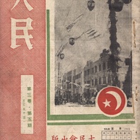
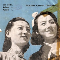
Huanan huabao (South China Graphic) cover, January 1941
This cover image is taken from Huanan huabao (South China graphic) 3.1 (January 1941). The staged photograph deploys one of the standard tropes of Japanese propaganda in occupied China, i.e., that of a Japanese woman and Chinese woman fraternising with each other. This trope was derived from Manchukuo propaganda and the notion of “gozoku kyōwa” (“the harmony of the five races”), as well as attempts to feminise the image of an occupied China. Note how the Japanese woman is pictured as being slightly higher than her Chinese peer.